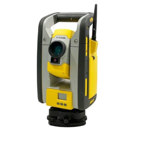
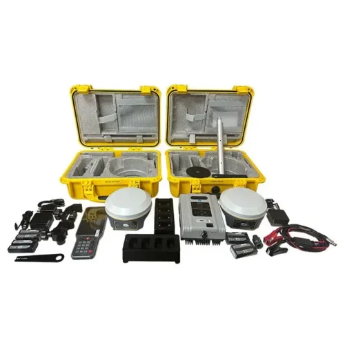
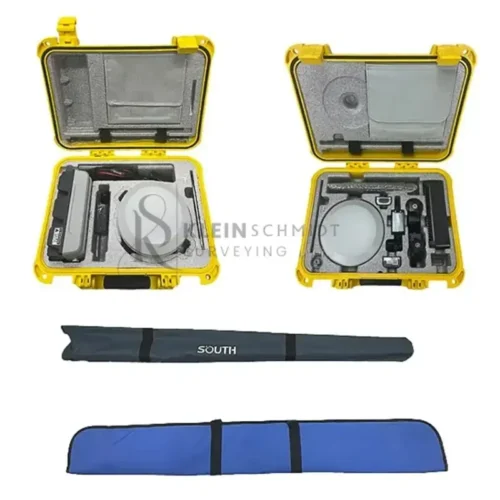
Description
The South G9 GNSS RTK GPS is a cutting-edge GNSS receiver for land surveying and construction. With advanced Intelligent Base Signal Locking technology, ultra-long 10km working range, and high-performance IMU tilt compensation, this GPS receiver with IMU tilt sensor boosts your productivity by up to 30%. South Galaxy G9 Designed for convenience and reliability, it integrates Bluetooth, Wi-Fi, and GSM antennas for seamless field operations. Experience exceptional performance with its dual-battery system and 15-hour battery life. Ideal for land surveying and construction, this device ensures efficiency, precision, and reliability.
Why Choose the South G9 GNSS RTK GPS?
- Precision and Accuracy: Reduce signal interference with Intelligent Base Signal Locking technology.
- Versatility: Ideal for land surveying and construction projects.
- Efficiency: Increase productivity with IMU tilt compensation and seamless integration of antennas.
- Reliability: Enjoy extended battery life and uninterrupted workflows with hot-swappable batteries.
South G9 Feature
Solve Your Surveying Challenges with Precision
Surveying can be time-consuming and frustrating, especially when faced with signal interference or uneven terrains. The South G9 RTK GNSS Receiver is here to solve these problems. Designed for professionals in land surveying and construction, this advanced GNSS receiver combines innovative technologies to ensure precision, efficiency, and convenience.
Intelligent Base Signal Locking Technology for Unmatched Accuracy
The South Galaxy G9’s Intelligent Base Signal Locking technology ensures consistent and accurate signal tracking. By using one-to-one signal tracking and locking, this GNSS receiver reduces cross-frequency interference even in crowded areas with multiple base stations. Say goodbye to lost signals and hello to uninterrupted workflows.
Ultra-Long Working Range and Unmatched UHF Performance
With its SOUTH high-performance UHF module and Farlink communication technology, the G9 achieves a 10km ultra-long working range. This enhances signal sensitivity and transmission efficiency, allowing you to work confidently over large areas without compromising on accuracy.
Seamless Integration for Field Efficiency
The South Galaxy G9 integrates Bluetooth, Wi-Fi, and GSM antennas into its GNSS antenna, providing a seamless and user-friendly experience. Whether you’re using it as a GNSS receiver for land surveying or a GPS set for construction, this device streamlines your operations for maximum efficiency.
Advanced IMU Tilt Compensation for Versatile Measurements
Uneven terrains are no challenge for the G9. Its built-in IMU automatic compensator allows for tilt measurements up to 60°, eliminating the need for strict leveling. Even if the fixed solution is temporarily lost, the system’s quick recovery ensures uninterrupted productivity. With IMU tilt compensation, you can stake out points or measure quickly and accurately, increasing your efficiency by up to 30%.
Powerful System Management for Reliable Performance
The G9’s Smart ROS system intelligently manages multi-mode hardware components for optimized performance. Coupled with an ultra-fine memory management mechanism, this GNSS receiver offers smooth and fast operation, ensuring you get more done in less time.
Long-Lasting Battery for Extended Field Work
With its dual-battery system, the South Galaxy G9 can work continuously for up to 15 hours in Rover+Bluetooth mode. The hot-swappable batteries allow you to replace them without turning off the device, ensuring uninterrupted workflows in demanding environments.
South G9 Specification
| GNSS Features | Channels | 1598 |
| GPS | L1C/A, L2C, L2P, L5 | |
| GLONASS | L1C/A,L1P,L2C/A,L2P,L3* | |
| BDS | BDS-2: B1I, B2I, B3I BDS-3: B1I, B3I, B1C, B2a, B2b* |
|
| GALILEO | E1, E5A, E5B, E6C, AltBOC* | |
| SBAS(WAAS/MSAS/EGNOS/GAGAN) | L1C/A, L5* | |
| IRNSS | L5* | |
| QZSS | L1, L2C, L5* | |
| MSS L-Band | BDS-PPP | |
| Positioning output rate | 1Hz~20Hz | |
| Initialization time | < 10s | |
| Initialization reliability | > 99.99% | |
| Positioning Precision | Code differential GNSS | Horizontal: 0.25 m + 1 ppm RMS Vertical: 0.50 m + 1 ppm RMS |
| Static(long observations) | Horizontal: 2.5 mm + 0.1 ppm RMS Vertical: 3 mm + 0.4 ppm RMS |
|
| Static | Horizontal: 2.5 mm + 0.5 ppm RMS Vertical: 3.5 mm + 0.5 ppm RMS |
|
| Rapid static | Horizontal: 2.5 mm + 0.5 ppm RMS Vertical: 5 mm + 0.5 ppm RMS |
|
| PPK | Horizontal: 3 mm + 1 ppm RMS Vertical: 5 mm + 1 ppm RMS |
|
| RTK(UHF) | Horizontal: 8 mm + 1 ppm RMS Vertical: 15 mm + 1 ppm RMS |
|
| RTK(NTRIP) | Horizontal: 8 mm + 0.5 ppm RMS Vertical: 15 mm + 0.5 ppm RMS |
|
| RTK initialization time | 2 ~ 8s | |
| SBAS positioning | Typically < 5m 3DRMS | |
| IMU | Less than 10mm + 0.7 mm/° tilt to 30° | |
| IMU tilt angle | 0° ~ 60° | |
| Hardware Performance | Dimension | 154mm(φ)× 106mm(H) |
| Weight | 1.3kg (battery included) | |
| Material | Magnesium aluminum alloy shell | |
| Operating temperature | -45℃ ~ +65℃ | |
| Storage temperature | -45℃ ~ +85℃ | |
| Humidity | 100% Non-condensing | |
| Waterproof/Dustproof | IP68 standard, protected from long time immersion to depth of 1m IP68 standard, fully protected against blowing dust |
|
| Shock/Vibration | Withstand 2 meters pole drop onto the cement ground naturally | |
| Power consumption | 2W | |
| Power supply | 6-28V DC, overvoltage protection | |
| Battery | 7.4V 3400mAh x 2 rechargeable, removable Li-ion battery | |
| Battery life(Dual-battery) | 15h(Rover Bluetooth mode) | |
| WIFI | Modem | 802.11 b/g standard |
| WIFI hotspot | AP mode, Receiver broadcasts its hotspot form web UI accessing with any mobile terminals | |
| WIFI datalink | Client mode, Receiver can transmit and receive correction data stream via WiFi datalink | |
| Communications | I/O Port | 5-PIN LEMO external power port + RS232 7-PIN LEMO(USB, OTG and Ethernet) 1 PPS data interface SIM card slot(standard) |
| Internal UHF | Receiver and transmitter 1/2/3W (Just receiver 0.01W for Russia) | |
| Frequency range | 410 – 470MHz | |
| Communication protocol | Farlink, Trimtalk450s, SOUTH, HUACE, ZHD | |
| Communication range | Typically 10km with Farlink protocol | |
| Cellular mobile network | 4G network communication module | |
| Bluetooth | BLEBluetooth 4.0 standard, Bluetooth 2.1 + EDR | |
| NFC Communication | Realizing close range (shorter than 10cm) automatic pair between receiver and controller (controller requires NFC wireless communication module else) | |
| Data Storage/Transmission | Storage | 16GB SSD Automatic cycle storage (The earliest data files will be removed automatically while the memory is not enough) Support external USB storage |
| Data transmission | Plug and play mode of USB data transmission Supports FTP/HTTP data download |
|
| Data format | Static data format: STH, Rinex2.01, Rinex3.02, etc. Differential format: CMR(GPS only), CMR+(GPS only), RTCM 2.3, RTCM 3.0, RTCM 3.1, RTCM 3.2 Navigation data format: NMEA 0183, PJK, Binary code Network model support: VRS, FKP, MAC, fully support NTRIP protocol |
|
| Sensors | Electronic bubble | Controller software can display electronic bubble, checking leveling status of the carbon pole in real-time |
| IMU | Built-in IMU module, calibration-free and immune to magnetic interference | |
| Thermometer | Built-in thermometer sensor, adopting intelligent temperature control technology, monitoring and adjusting the receiver temperature | |
| User Interaction | Operating system | Linux |
| Buttons | Single button | |
| Indicators | 4 color LED indicators, Battery indicator | |
| Web interaction | With the access of the internal web interface management via WiFi or USB connection, users are able to monitor the receiver status and change the configurations freely | |
| Voice guidance | It provides status and operation voice guidance, and supports Chinese/English/Korean/Spanish/Portuguese/Russian/Turkish | |
| Secondary development | Provides secondary development kit, and opens the OpenSIC observation data format and interaction interface definition | |
| Cloud service | The powerful cloud platform provides online services like remote manage, firmware update, online register and etc. |